
Dubai to Install New Street Signs in Five Colours Reflecting District Identities
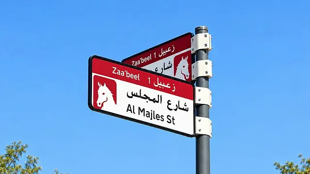
Dubai will begin rolling out a new urban addressing system in the final quarter of 2026, featuring redesigned district signs, street-name signs and building number plates in five colours reflecting the characteristics of each area. The scheme is expected to cover 186 areas across the emirate by 2030.
In the first phase, more than 2,000 signs will be installed or replaced in Za’abeel 1, Za’abeel 2, Nad Al Sheba, Al Khawaneej 1 and Nazwah. Sign colours will reflect local environmental features, with blue designated for coastal areas and gold for desert areas. Details of the other three colours have yet to be announced.
The new system will be implemented by Dubai’s Supreme Committee for Urban Planning in coordination with the Roads and Transport Authority and Dubai Municipality. It will include signs identifying areas and urban sectors, street-name signs and building number plates.
The new building plates will display the property number, Makani number and a QR code. By scanning the code, users will be able to access information including the area and urban sector, street and district names, and nearby landmarks.
The new visual identity will later be extended to bus stops, mobile applications and area map signs. Dubai officials said areas would be prioritised based on factors including population density and growth, the presence of residential communities and tourist attractions, and the number of streets that do not yet have official addresses.
The visual identity for Dubai’s new addressing system was approved by the Dubai Executive Council on July 1, 2026. The initial announcement envisaged covering 186 areas by 2029, but the latest implementation plan sets phased completion for 2030.